Searching for Gino Watkins 2016 - The Expedition.
The journey to East Greenland is now a well worn path. After sixteen years Martin Rickard
http://seakayakadventures.co.uk/ has assisted many paddlers from the UK, and other places from all around the world, to enjoy the paddling, wild life and culture of this unique location.
Martin was already in Tasiilaq having already completed one trip so after flying from London Heathrow I met the other team members the following morning at the Downtown Hostel Reykjavik. Donna was on my ill fated 2014 trip and it was great to meet her again in much better circumstances. Geoff had visited Greenland recently with his wife and he was now ready to embark on our new venture. John had flown in from Copenhagen and was just as keen to get started.
After more than one coffee we decided to pay a visit to the Whale Museum which is situated near to the large harbour complex. The Museum provides each visitor with a tablet and ear phones at the reception. You are then free to wander around the full size exhibits whilst being educated as to each species' appearances, food, habits etc. This was to prove very useful later in the trip.

As usual the rain was bucketing it down in Reykjavik and we were more than pleased to get on the morning flight to Kulusuk the next day.
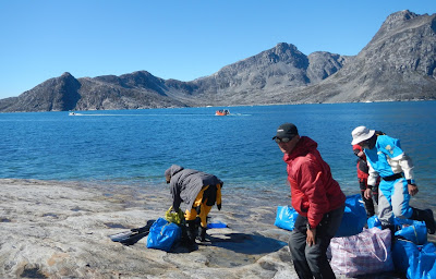
We met the members of Martin's previous trip in the small airport terminal and were given a brief insight into their experiences. Apparently they had seen Whales virtually every day they were paddling and noted at least five different species. It was a Bluebird day for our arrival and Greenland was looking its best for us. We managed to flag down a local 4 x 4 and for a suitable fee the driver dropped all our kit down to the quay for us. This was a relief because with my food and kit I was carrying over 40kg. Geoff with his camera equipment was carrying considerably more and its about 1.5 Km from the airport down a dusty road to the quayside.
The boat pick up was on time and already waiting. It did not take us long to load our gear and we were soon on our way. There was little ice about and the sea was flat calm so we had a smooth ride over to Tasiilaq. Morale was high with lots of friendly banter. We were all excited at being back on Greenland waters. This is such an amazing place.

Martin was on the rocks near Vietnam Beach and helped unload all our gear and carry it up to the camping area. We call this site Vietnam Beach because the Heliport is situated right next door and we are regularly buzzed by numerous helicopters. The large one which connects with Kulusuk airport is bright red and looks and sounds like something from Apocalypse now. We do need to rig up some large speakers so that we can blast out The Ride of The Valkyries.
All of us had done this before so we quickly got our tents up and reacquainted ourselves with our boats. It felt good wandering around Tasiilaq. The hills did not seem so steep this time and I knew where everything was. We visited the Tourist Information Office at Destination East Greenland and the large Pilersuisoq supermarket to buy gas canisters for our stoves. Gas has only been readily available here for the past three years and this was the first trip that we could rely only on gas and not petrol which is smelly and dirty and a pain to carry on a kayak. I managed to purchase a large hand line for fishing. I was hoping to catch some Cod similar to the ones I caught two years ago when Mikkel, a local hunter took me on a fishing trip out of Tasiilaq.
We eventually made our way to the one and only bar in Tasiilaq. The coast of East Greenland is 2700km long and has a population of only four thousand people. Two thousand of these people live in or around Tasiilaq and a bar is quite rare in these parts. The bar was empty when we entered. It had been done out since I was last here with a large flat screen tv, posh subdued lighting and new timber furniture. We took a table in the corner and started to swap sea kayaking stories. Soon the bar started to fill with locals. Seven o'clock is Bingo time and this is very popular. The locals were a little surprised but obviously excited to see us and soon our table was surrounded by lots of smiling faces curious to know who we were and where we from. The questions flew fast and quick. 'where you from ?' - Wales, have you heard of Wales? ' yes of course, Gareth Bale'
Where you from ?, Tasmania, where? Australia ah yes we have heard of Australia.
Rasmus drew up a stool and started to interrogate Donna. Where you from? USA ah yes America. Their English was broken at times but a lot better than our Greenlandic. Rasmus was fascinated that Donna was a Grandmother and reckoned that she was 'awesome' He had some strong views on the fact that Greenland had Uranium and we were asked to share our opinion on this.
Eventually we were asked what we were doing in Tasiilaq. We explained that we were going to Tugtilik which did not go down too well because it was a long way North and the ice was dangerous. When we then explained that we were going by kayak we were told ' Ah so - You are not Tourists, you are Kayakers.'
Wednesday 27 July
First day of the Expedition proper. The pick up boat was due at 11 am. We packed our kit and dropped any kit not needed on the trip up to the steel containers which form Martins base in Greenland. It would stay there for nearly three weeks where all of it would then acquire the distinctive smell of fibreglass, but at least that would help to hide the fact that we would not shower in all that time.
We managed a last minute shop for cakes and coffemate. Geoff and myself were able to sneak into the new Community building for a last visit to a flush toilet. This would be the last one until we got back to Iceland in three weeks.
Two boats arrived, one for us and our kit, the other one for the kayaks. The sun was out and it was very warm. We donned our drysuits but left the tops down and wore our normal coats on top. We were due to make a wet landing on to a beach or rocks and did not want to get soaked. Once near to the water the temperature dropped noticeably and when the boat was under way the wind chill dropped the temperature even further. It is very easy to get caught out like this. The boat had a cover to the front but was fully loaded. The kit had to be moved aft to trim the boat and allow it to get onto the plane.
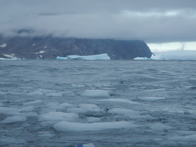
We headed out of Kong Oscars Haven which is the Fjord that leads to Tasiilaq and its harbour. There were some huge icebergs at the entrance which provided good photo opportunities. We first headed East back towards Kulusuk and then North up Angmagssalik Fjord. Once opposite to North End of Angmassalik Island we turned right into a very picturesque Fjord that I had paddled three years ago. There is a marker post at this junction to show the way. The sea conditions were good and we wanted to take the route outside of the islands up to Sermiligaq.
The journey was 80 km in bright sunshine and on a calm sea, conditions could not have been better. Our plan was to land on a beach West of Sermiligaq and then paddle North for a couple of hours to the 'Slabs' campsite just South of Sarfaq Pynt. Because the conditions were so good we were able to persuade the boat drivers to take us direct to The Slabs. This saved a lot of faffing packing and unpacking the kayaks.
We call this campsite The Slabs because the landing is direct onto large flat and smooth rocks. There is no beach at all. The boats were unloaded and we waved goodbye to the drivers. The time we gained enabled us to chill for the remainder of the day sorting our kit and practising packing the kayaks. This set us up for a great start the following morning. We were now on our own for the next seventeen days. We set up our tents but left the fly sheets off until the sun started to set behind the mountains because it was so warm. Just South of the campsite back towards Sermiligaq there is a small water source where we were able to top up our water bags. I had a go at fishing with my new hand line and Geoff had plenty of time to practise setting up his bear trip wires. Geoff had more success than I did.
Thursday 28 July
Our first day paddling. We quickly got into the routine of breaking camp and packing the kayaks. Launching the kayaks requires a full team effort as it takes four of us to lift one fully loaded kayak. We first headed North and turned around Sarfaq Pynt in a South Easterly direction. There were large ice bergs here and a numerous Glaciers to the North.

We needed to top up our water bags once more and found a large waterfall just before we rounded a headland to turn North East. There were no landings between The Slabs and this waterfall. John volunteered to take one for the team and swam ashore. We all passed him our bags and he topped them up whilst getting totally soaked. The cold climate ensures that the water supply is always pure in East Greenland. Some supplies contain gritty deposits but if the water is fast flowing this is not so much of a problem.

After putting John back in his boat by way of a wet entry we rounded the headland and paddled North East straight into a headwind. At the top end of Jerne Sund there is a very small gap which separates the little island of Annlinarteq from the mainland.

Once through this small gap you arrive in Jerne Bugt. This is a sheltered Fjord with glaciers and mountains to the North and West. There is a sandy beach just past the gap on the East side of Annlinarteq. This is a prefect place to have lunch and gave us a chance to stretch our legs. The water is crystal clear.

After lunch we headed North East once more towards the next small gap at Smalsund. Once through Smalsund the island of Gruse (Aputiteq) appears in the distance. This was our next campsite. This island is mentioned in Freddie Spencer Chapmans book ' Watkins Last Expedition' and in 1932 apparently had its own ice cap. Today there is very little ice to be seen. The crossing to Gruse is less than one thumb (5nm) and takes under an hour. The landing beach is on the East side and is marked by a hut that is positioned on a headland.

The hut is very difficult to spot as you cross from Smalsund but soon appears above you as you traverse the shore of Gruse. The beach is sandy at low tide but there are only rocks when the tide is high. The kayaks have to be lifted well clear of the sand and secured with a rope. This is because to the West is an ice berg grave yard and at least three glaciers. The ice bergs and glaciers calve all the time so it is like camping near to a battlefield. The ice bergs crack and the glaciers boom but you rarely see the ice falling because of the time it takes for the sound to travel across the fjord. This is truly an amazing place to a camp although the terrain does resemble the moon.
Once again we set up camp leaving the fly sheets off and and had a snooze.
The average age of our team was fifty eight. None of us had signed up for a mile munching mission and we knew that to succeed and get to our objective we needed to take it steady and keep ourselves safe by not pushing the boundaries. With this in mind we were determined to stay relaxed.
We visited the hut and read the notes of previous trips which are inscribed on the wall. We resolved to write our names up on the way back but only if we got to Lake Fjord. Much to our annoyance a family had visited recently and wrote their names. No problem with this but after eight years Martins pen was missing.
The temperature dropped after the sun went behind the mountains and we manged to light a campfire with some drift wood. We agreed on a rota and stood bear watch for the first time which meant I slept late.
Friday 29 July
Today was going to be a short paddle of about three thumbs or three hours. The first hour would take us to the twin islands shown on the map as Qavtunaq and Fladoerne. The next landmark after the islands is the headland at Kangikajik approximately one thumb away. The final leg is an open crossing to Depot Island one thumb to the North East.
My lie in was not a problem as we were due to leave at around ten am. After breakfast we moved the boats closer to the water and loaded them on the beach. I hate being the last to launch. I am a notorious faffer and my son often issues the rebuke 'faff like this in Greenland and you going to really p**s people off'.
There was the usual Greenland fog at high level and there was a noticeable drop in the temperature. I have learnt my lesson from the 2014 trip and wore my dri suit and thermal base layer. The icebergs were constantly calving and there were some very large ones which were quite close. These produced a few waves which was a little unnerving.
We had a slight tail wind and we were soon passing between the two islands noting beaches and possible landing sites as we went. There were some huge ice bergs just after Qavtunaq a couple were as big as skyscrapers and one was rocking to and fro and was obviously about to flip. The crossing to the headland was not particularly quick due to the number of photographs being taken. At the headland we took a short rest and a coffee break. I have two large neck flasks, Whilst cooking breakfast I put soup in one and coffee in the other so that I can have a hot drink on the water if we cannot land for lunch.
The crossing to Depot Island was straight forward (not like last time ) and just before landing we managed a little rock hopping between two small islands. At high water there is no beach at Depot Island but today there was a small tide and we arrived shortly after the tide had turned. We unloaded the boats and had a late lunch on the beach.
The campsite is a bit of a scramble off the beach so it was a something of an effort to carry up all the kit. The island has been well used in the past. The place was littered with various items of rubbish including sled dog ties which had been chewed through. We assumed that the locals must use this site in the winter months when out dog sledding. There are the remains of a turf a house which I had photographed when I visited in 2014. Depot Island was the furthest north I managed to get before the rescue boat came and took me back to Tasiilaq. I had a few Ghosts to lay was very happy to have got back here feeling as good as I did.

The boats were moved into a gulley well clear of the beach and after our evening meal John and Geoff went off for to explore. Close to the campsite there are some burial sites, small standing stones and stone caches which is where the island presumably gets its name.
Saturday 30 July
The expedition routine sounds boring when it is written down. Get up, pack up, breakfast, move boats, load boats and launch. However, the routine is far from boring when you are in a place like East Greenland. The views are always spectacular and are changing constantly. There are mountains, glaciers and Fjords. We are always looking to see what the weather is doing, watching the clouds, the wind on the water and any thing that may help us to make sense of what is happening around us. There is also constant banter between each of us which keeps your mind alert for a suitable response or riposte. When paddling it is quite easy to end up out of ear shot from the others so on a long day you sometimes become engrossed in your own thought while you paddle. An ipod or something similar helps.

Today there was a lot of Greenland fog around. It lingers between the mountains and in the fjords. We call this The Dragons Breath back in Wales. We had breakfast gathered around a large rock and launched off the sandy beach as the tide was still on its way in. The first part of the paddle was due north further into Depot Fjord and along the east shore of Depot Island. After a short while we turned east into a small channel between Depot island and the main land noted on the map as Depot sund (Ananap ikasa). There were some large ice bergs in the channel some of which were active and calving as we passed. We kept well clear of these and were soon in a maze of small islands. The fog closed in as we paddled close to ice bergs so large that the tops disappeared upwards into the fog. To the left of us the cliff tops also disappeared into the fog. Navigation was quite difficult so we resorted to using the GPS to keep track of our progress. A compass does not work very well here and the GPS gave us a degree of confidence. Martin had been here a few times before so that helped as well. We rounded a headland and passed to the east of an island (Nipinerit) and across a small bay to another headland Kap Nordenskiold.
We were heading for the east side of the island of Store. This island is mentioned many times in Freddie Spencer Chapmans book but it is referred to as Sartermie. The paddle from Kap Nordenskiold to the hut at the north end of Store is at least two thumbs (two hours) and we needed to cross the channel between the mainland and Store. The trouble was that we could only just see the cliffs to the west of us and we could see nothing of Store. Using the GPS we crossed over to the bit of land marked Nugartineq and just to north east of an anchorage shown on the map. Whilst we were crossing we heard an iceberg calving just behind us. The noise went on for at least five minutes and we assumed that one of the huge ice bergs that we had just passed had in fact rolled. We were disappointed because due to the fog we saw absolutely nothing.
We paddled around a small headland and picked up a light tail wind. This wind was enough to clear some of the fog from sea level and slowly the mountains came into view. It seemed that the further north we went the better the views just got better.
A small sandy beach on the west side of Store was an ideal place to stop for lunch. This one had the benefit of a stream at the southern end where we could top up our water bottles and bags. There was no water at the Depot Island campsite.

After lunch we once again headed north and eventually came to the two huts at Satermit where we landed intending to make camp. The landing is in a rocky gulley and it was not easy to get the loaded boats out of the water. We tied off the boats and left them floating and went to have a look around the huts. The site is well used by local hunters and was in a bit of a mess. The second hut did not have a door and the sleeping bench had been dismantled. With the amount of litter and debris lying around this was not going to be a very comfortable place to stay.
After a team meeting in the main hut we decided to head further along the coast and explore the area around Eskimo Island to the east of Store. We arrived at the channel between Eskimo Island and Store and paddled in to a large bay Imartineq. There were some impressive ice bergs here but nowhere to land let alone camp. The time was now approaching eight o'clock and we had been on the water since nine that morning. We were near to the mouth of Kangerdlugsuatsiak. To the north we could see a large headland the other side of which was Hell Corner. To the east there was nothing but The Denmark Strait so this was not a place to hang around at this time of night and we needed a campsite.
We decided to head back to the two huts. After about an hour we spotted a small beach with a reef to right hand side of its entrance . We landed and after a brief explore we found a nice campsite just off the beach up some loose rocks to the right. This campsite is marked Saningivajik on the map.
We made camp and had our evening meal on the beach. Martin managed to get a weather forecast for the next few days. The next day it was due to be a little windy but after that the forecast was for light winds. We decided to have a rest day and head across Kangerdlugsuatsiak the day after.
Sunday 31 July
There was low cloud this morning which somewhat spoilt the fantastic views today. We were camped in a small valley a little above sea level. To the south of us the cliffs rose steeply which meant we were in shadow until the sun rose high enough to clear them. To the north the ground went up gently to form a gnoll. The normally wet mossy ground was completely bone dry due to the lack of rainfall recently. In normal conditions this would be quite a damp spot.

After chilling in the tent, reading and listening to music, I went for a walk up to the top of the gnoll. The view was stunning, probably the best view that I have ever seen. Kangerdlugsuatsiak is about two thumbs (10 nm ) across. On the far side to the north were four well defined hanging valleys each with its own glacier. To the east the fjord gives way to the open sea where the swell picks up. In the opposite direction to the east there is a junction of four fjords. Straight across is Nordfjord where FSC and co. put in to repair their motor boat the Stella. Next to that is the main fjord which leads to the Glacier de France. The other two fjords are Vestfjord and Odesund which is the channel between Store and the mainland.
I had another go at fishing, this time spinning off the rocks. Despite moving to various locations to all the seaward sides of the gnoll I did not get so much as a nibble. Other ways of passing the time included taking pictures of the food pouches for our kind sponsors. Geoff the team photographer was kind enough to give me some tips which I think improved the standard of my pictures. John felt restless so he paddled back to the huts at Satermit to get some firewood. We kept in touch by radio just in case he encountered an ice bear. The locals do not know them as Polar Bears. In any case the sun had gone behind the cliffs and we had a big day ahead of us so we went to bed early. It was not getting dark at all so as Gino Watkins once apparently said 'the hands on the clock were meaningless'.
Monday 01 August
We awoke early to a lovely morning. The cloud had all gone and it was a beautiful bluebird day.
Our routine was the same as normal and after breakfast on the beach we packed the boats and headed diagonally across Kangerdlugsuatsiak Fjord. Under the hanging valley furthest to the right (east) there is a beach where it is possible to land and have a break before assessing the situation and making the final decision to head off towards Hell Corner. The crossing took just under two hours and the past surprisingly quickly which was probably due the views of the coast and icebergs. About half way across a whale past just behind us. Using mu new knowledge from the Whale Museum in Reykjavik i reckoned it was a Hump Back Whale. I made a rather poor attempt to video it.
The beach is in a small cove sheltered from the open sea by a low headland. At the rear of the beach the cliffs rise sheer and the steep slopes are covered with scree. The tide nearly covers the sand at high water making this more of an emergency or lunch type beach. some of the loose rock looks rather precarious.

We had a quick coffee break and refilled our water bottles from a noisy stream that was cascading out from under a large block of ice. This stream was probably fed from a glacier in the hanging valley above us.
Once back on the water we hand railed the cliffs and made our way to the mouth of the fjord. A few kilometres on there is a large bay which marked the transition between the Fjord and the open sea. We had a quick conference to make sure that everyone was happy to proceed. From this point there was at least a five hour paddle in front of us with nowhere to land. It was important to make sure that we were all comfortable. The decision was unanimous and we set off once more.
There was a small chop and a gentle tail wind. Conditions were as perfect as we could have expected. We kept fairly close to the cliffs which meant that sometimes we took the inside line when passing an ice berg and sometimes we went around it. As usual the ice bergs were calving and the sound of breaking ice kept us on our toes.

After a couple of hours Hell Corner (Qagitsivigtaqartarajik) came in to view. The headland is quite distinctive and it has what appears to be a small triangular cave at sea level. There is a reef which heads out to sea from the base of the cliff directly off the point. The water was kicking up even on a calm day such as this which is probably due to a number of currents meeting at the headland.
We rafted up just before Hell Corner and carried out an assessment. John produced his large bag of sweets and we were all feeling quite excited. We had read about this place but I had only ever seen one photograph taken by Paul Caffin on his visit to Lake Fjord. In any event the paddle past the headland although choppy was fairly uneventful.
From Hell Corner it is just over a kilometre to Kap Japetus Steenstrup ( Nigertulup orqngmut nua ) and the entrance to Nigertulik Fjord. FSC refers to this fjord as Nigertusok. According to FSC the fjord gets is name from the strong north easterly winds that blow down the fjord from the glaciers which we could see to the north west as we paddled across. The entrance is nearly a thumb wide and it took us a little under an hour to get to the other side. There was a bit more chop here so taking pictures as we crossed was little tricky. Once across we cut inside a group of islands and looked for somewhere to have lunch. There was a sheltered bay behind the biggest island but there was nowhere to land even though Martin and John had a good look around. We rafted up once more and had lunch afloat.

After lunch we paddled along the coast and cut inside the next island through a small channel. As we emerged from this channel we could see a large island sitting at the mouth of the next fjord. This island was named Ailsa by the BAARE Expedition due to its resemblance to Ailsa Craig an island just off the coast of Scotland to the west of Girvan in the Forth of Clyde. Ailsa was easily recognisable and this confirmed that we were now at the entrance to Lake Fjord.

FSC describes the fjord on page 38 of his book. It seems a bit pointless to write about the same place and merely change the words so I take the opportunity to quote him here:
'Lake Fjord is a small Y shaped fjord, the extremities of which are only 3 or 4 miles from the open coast. A high conical island of rock, reminiscent of Ailsa Craig , after which we named it , guards the mouth of the fjord, which is rather more than a mile in width. The steep - sided north branch of the fjord terminates in a glacier wall nearly 100 feet in height, running the whole width of the fjord. This glacier, longitudinally streaked with lines of moraine debris, is fed by many tributary glaciers winding round the feet of lesser mountain ranges visible in the background. On the north side of this fjord is a narrow hanging glacier of extreme steepness.
The southern branch of the fjord leads through less rugged mountains to a wide fertile valley containing the lake, bringing down so much mud that ships must anchor long before they reach the end of the fjord'
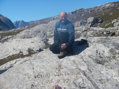
We encountered a head wind as we entered the fjord and this created a small chop on the water and this gave the impression that the tide was flowing out of the fjord. To the left the cliffs towered above us and blocked out the sun creating a large area of shadow which was quite cold. The rest of the team chose to paddle further out in the main channel in the sunshine where they could get a better view of the glacier in the right hand branch. I took the colder route close to the cliffs out of the flow. Slowly Aisla drifted behind us and the features of the coastline at the branch junction took shape. I kept focusing on this point because this is where the memorial cross to Gino Watkins is marked on the map. Not far from this point we regrouped and eventually the cross came into view above us. We had decided to land here on the way in and visit the cross first. This would give us the option of leaving in a hurry if the weather forecast took a turn for the worst. With a seven hour paddle behind us we were feeling rather exposed.

The landing to view the cross is not an easy one. Just off to the left (west) there is a small ledge which forms a bit of a quay. The state of the tide was perfect and there was only a small swell. John landed first and assisted us each in turn. Even so, for us old folk it proved to be a bit of an effort but no one got unduly wet. We tied off the boats and cast them adrift connected by a tow rope secured to a rock. From here it was a small sometimes vertical scramble up to the site of the cross.

The view from the cross is quite spectacular and it was easy to why this spot was chosen. Ailsa is clearly visible as its it splits the entrance to Lake Fjord in two.

We each had our photographs taken and congratulated one another on getting here at last. We had all wanted to make this trip for a long time and this was my second attempt. Our team had an average age of fifty eight. Martin reckoned that only fourteen paddlers have ever paddled in and out again (excluding locals of course) and Donna is the only women to have achieved this so far. By the way apparently I may be the oldest to have done it.
I had mixed emotions, on the one hand I was feeling as if I had climbed a mountain and was standing on the summit but this was tinged with the fact that we would not be here if Gino Watkins had not died in such tragic circumstances. In any event it was not hard to have a sense of closeness to the characters brought to life by the books we had read.
Time was getting on, we had been paddling for over eight hours and we needed to get to the campsite which was half a thumb up the left (west) branch of the fjord. We retraced our steps back to the boats and successfully got afloat without any mishaps. As we paddled further in to the fjord we past many grounded ice bergs blown here by the wind. We had fun making Disney shapes from them. I clearly saw rabbits, chickens, Shrek and many others.

We landed by a scree slope with lots of debris flowing into the fjord from the glacier above. Further round to the left a river flowed into the sea from The Lake. As stated by FSC the tide goes out a long way here and we were fortunate to land near to high water. After securing the kayaks we quickly found the site of the old hut and set up camp nearby.

We explored the hut and the surrounding area. It was possible to make out the remains of the old water supply and a fish smoker. We examined what remained of the hut and found some smaller items such as sardine tins, marmite jars and other various bits n bobs. There were cables tied to rocks presumably to tie the hut down in windy conditions. Local hunters visit the fjord but they appear to camp away from the site where it is easier to land at low tide. The base camp site is surrounded by a lot of wild flowers and there are quite a few birds flying about. There is also the constant sound of running water flowing through the glacier debris near the shore. At the base of this debris Donna and John discovered the remains of an old boat. We retrieved the keel and excavated sand and rocks to reveal one side of the boat. It was about 5 metres long and quite sturdily built. Donna had a copy of FSC's book which had photographs in it. On one of the pages was a photograph of John Rymill sailing the whaler which the expedition used for fishing and general ferrying of equipment. The boat that we discovered was clearly the same boat. FSC had written that this boat had been towed out of Lake Fjord at the end of the expedition but this does not seem to be the case. We took photographs of the boat and put what we had excavated in a safe place above high water.
Everyone seemed a little subdued possibly due to the days paddle or maybe due to the atmosphere of the campsite. We sat around a camp fire as the sun went down and I spoke a passage from FSC's book which was read when the original cross was erected.
Fear no more the heat of the sun
Nor the furious winter rages
Thou thy worldly task hast done
Home art gone and ta'en thy wages
Golden lads and girls all must
Like chimney sweepers, come to dust.
Tuesday 02 August - Hell Corner Return
It was a beautiful sunny day again, but I could tell Martin was feeling edgy. It is a big responsibility to lead a trip and take the rest of us to a place as exposed as this. There was no feeling of exposure at the base camp. The weather was good, the views were stunning and there was plenty to do and see. I wanted to stay one more day but in the back of our minds there was always Hell Corner and how difficult it would become if the weather changed. The decision was made to leave at 3pm that afternoon to take advantage of the high tide.
Before we left there were a couple of things that we wanted to do. Donna and John trekked up to The Lake to get some photographs. I went for an explore around the locals campsite. On page 89 of FSC's book he refers to having breakfast with some of the crew of The Maegen a Danish Naval ship that was used for fishery protection on the West Coast of Greenland. This ship had given FSC and Quinten Riley a lift from Angmassalik to Lake Fjord.
'When Commander Reis and Lieutenant Hoppe came to breakfast with us in the hut next morning, the former told us that he had a man on board who had once been a stone-cutter and that if we agreed he would get him to carve Watkins' name and the date of his death on a large lump of granite just behind the base.'
This is the only reference that we have read which relates to this carving and none of us had ever seen a photograph. Martin had been to Lake Fjord twice before and despite looking for the carving he had not found it. We went back to the book and started again. 'Behind the hut' we assumed this meant within say fifty metres. By holding a burial service the remaining expedition members confirmed their Christian faith so the carving would probably face east. The 'large lump of granite' would need a flat section big enough to fit the lettering on it. I located a suitable section of rock on a low granite ridge behind the hut and we carried out a finger tip search. By this time Donna and John had returned from The Lake and almost at once Donna spotted an ornamental cross. We then found Gino's name and the date of his death exactly as stated in the book.

The inscription was difficult to read and did not show up in photographs so we coloured in the letters and numbers with a lump of coal from the left over supply at the hut. The carving then became clearly visible. I placed a sprig of Niviarsiag (Chamerian latifolium or dwarf fireweed/River Beauty) the national flower of Greenland below the writing and we each had a photograph taken in memory of our visit. The rain will by now have washed the coal away and Gino's name will be hidden once more.
We launched on time at 3pm and headed away down the fjord. As I passed the trapped ice bergs I once again made disney shapes. There was a head wind from base camp to the branch fjord. We kept close to the south shore in the shadow created by the large cliffs. Ailsa soon appeared dominating the view to the north and dividing the fjord in two. We found the small gap inside the first island and rounded the headland into the large bay north of Nigertusok. By this time we had been paddling for about an hour and a half so we rafted up and had a coffee break prior to the crossing of Nigertusok Fjord. After crossing the mouth of the fjord we retraced our route back to Cap Steenstrap. The sea became messy and bouncy as we approached Hell Corner. There was no pattern to the waves and we were under high cliffs constantly in shadow so it was quite chilly. The next couple of hours were not particularly interesting, we did not speak much and as a group we were quite spread out. Eventually the sun came into view shining off ice bergs out to sea. The view south to Eskimo island and Store, with all the different light patterns, was just beautiful. We rounded a headland and entered the mouth of Kangerdlugsuatsiak Fjord by the large bay. We landed on coffee break beach just after 8.30pm feeling a bit tired after the five and half hour paddle but quite elated that we had done it and got out without incident.
We had coffee and some food and launched onto a flat calm sea. The sun was starting to go behind the mountains and we had a beautiful sunset paddle passing each of the hanging valleys. We landed at 10.30 on a small beach at Ingmikerterajik and inside some huge ice bergs which were just a few hundred metres off the beach.

The boats were unloaded, moved above high water and secured with a tow line. The campsite was strewn with rocks interspersed with plenty of dry moss and covered in Niviarsiag. We set up camp and then spent time chatting and drinking hot chocolate. We were all feeling good and did not set the trip wires until after 1.30 am. It was still not dark and I was feeling apprehensive - this seemed like a good place for bears.
Wednesday 03 August - Rest day
It was a rest day but I was still up early. There was not a cloud in the sky and the views with the big ice bergs so close were once again stunning. A few hundred metres away to the west was a large stream flowing down the mountainside from a large glacier. This was a great place for a good wash down and a chance to rinse some salt out of our kit. We spent the time taking photographs, charging our batteries on the solar chargers and chilling on the beach. I watched a large group of Greenland seals swimming around the ice bergs. They then moved off along the coast and appeared to be shepherding fish to trap the against the shore. Greenland seals are quite peculiar to watch. They swim with their heads up and in groups presumably for safety.
We cooked dinner on the beach and then the temperature dropped. Mist came in and a large ice berg exploded just off the beach creating a small tsunami which luckily did not reach the boats.
Thursday 04 August - Return to Depot Island
Up early once again and launched just after 9am. We paddled through the large ice bergs but did not hang around too long. One had calved during breakfast about half a mile away and this was not a safe place to paddle, but we did get some good photographs and some video. It did not take too long for us to get out into Kangerdlugsuatsiak Fjord and we headed towards our previous campsite. From here we turned west passed the huts at Sartimit and landed on a small sandy beach for a bar and wee stop.
Once around the north end of Store we paddled into Odesund the small channel between Store and the mainland. The water was flat calm at first but a headwind soon picked up slowing our progress. By lunchtime we were at the main sandy beach halfway down Store where we had food and topped up our water bags. The headwind picked up again for our crossing over to the mainland where we paddled in the shadow of large cliffs in a choppy sea. There were some large ice bergs grounded at the base of the cliffs and we paddled once again inside some and outside others. The sea became even more messy and the waves were bigger than we had experienced at Hell Corner. We rounded a large headland, Kap Nordenskiold, and turned south west into a channel inside the island of Nipinerit. There are a lot of islands here, FSC describes them as a maize so you have to keep your wits about you. After Nipinerit we turned into another small channel Depotsund and headed northwest around the north end of Depot Island.On the shore there are the remains of a turf house and a wooden marker post. We had a good look around for a place to land but there was not a suitable spot so we continued to the main campsite at the south west corner of Depot Island and landed at just after 3.30 pm.
It was high water so we had to quickly unload the boats and move them into the gulley. It was then back into the normal routine of set up camp, brew and snooze. I was starting to switch from expedition mode into holiday mode and could feel the pressure coming off. Depot Island is a noisy campsite, the waves boom into the gulley at high tide. It was now getting cold after 6pm, the trip wires appeared to be working well so we decided to cook at the tent. After dinner Geoff and myself went for a walk up the hill. Here we found plenty of burial sites but no bones. There were also a number of stones jammed vertical into the rock. We could not fathom what these were for and assumed they were some form of navigation aid.
Friday 05 August
Short paddle day today back to Gruse. Launched at 10.15 and had a leisurely paddle across Depot Fjord to the headland at Kangikajik. On page 228 of his book FSC refers to three islands, Ananah, Katunah and Aputatik. We know that Aputatik is Aputiteq or Gruse. I am of the opinion that Ananah is Depot Island. FSC Says that the sea is vilely rough as they paddle in behind Ananah and there are old winter houses on the sheltered side of the island. The map refers to Depot sound as Ananap ikasa and Depot Fjord as Ananap kangeriva orqorteq. So Depot could easily equate to Ananap or Ananah. Of course this pure speculation especially as FSC does specifically mention survey work being carried out in Depot Fjord.
The other island Katunah is mentioned a few times as a stop over on the various journeys between Lake Fjord and Angmassalik but it is not shown on the map. One of the two islands at Fladeerne is named Qavtunaq and we surmised that this could in fact be Katunah. These islands were the next way point after Kangikajik and we decided to have an explore as we passed. The distance from Kangikajik to Qavtunaq is less than one thumb and we arrived at the islands in under an hour. We circumnavigated the easterly island which is the taller of the two. There was only one viable landing spot overlooking the sound between the two islands and we stopped for elevenses. We believe it is the westerly island that is Katunah. This island is low by comparison to its sister and it is possible to see the remains of winter houses and walls from the sea. We did not land and continued on towards Gruse.
We landed on the sandy beach and quickly unloaded the boats and set up camp. After lunch comprising flat bread and Brie we held a team meeting to decide where we were going to go next. All of us were keen to get up close to a glacier. We could go directly across to the Apusineq Glacier on the other side of the fjord from the camp. The glacier calves into the sea in a number of places and there seemed to be one spot where we could land and hike up the mountain alongside the glacier. The other option was to head north from Sermilgaq and visit the Karale Glacier. We decided on the second option. The Apusineq Glacier was very active and could prove to be a hazard and the Karale Glacier is massive by comparison.
Some of us went for a walk up on to the ridge behind the campsite. From the top of the ridge we could retrace our paddle all the way back around Hell Corner and on to Ailsa at the entrance to Lake fjord. There was a glacier pool where we went for a skinny dip. The first bath for nearly two weeks.

The terrain was a boulder field with some large rocks and patches of grit and dust much like I would imagine the Moon to look like. FSC says this island has its own permanent Ice Cap, but there is very little ice left today.

That evening we lit a camp fire and had a brew whilst Donna read passages from the book. We were travelling the same route that the BAARE members used many times on their trips to and from Lake Fjord. The glacier was especially noisy this evening and it sounded once again like we were sleeping close to a battlefield.
Saturday 06 August
Yet another sunny morning. We packed up early, had breakfast on the beach and launched just after nine. The ice bergs were very active today and minutes after we launched a set of very big waves arrived and went right up the beach and past where the kayaks had been tied off. This had a been a lucky escape for us.
Gruse was soon left behind us and we retraced our route through the gaps in the islands. There was a lot of brash ice here which makes a hideous noise as it bumps along the kayak. I felt quite guilty as I thought of Martins gel coat.
After lunch on the picturesque sandy beach we paddled through the small gap on the East side of Annlinarteq and on towards the next headland. As we rounded the headland the wind picked up to force four/five directly into our faces. We struggled to make headway and eddy hopped along the north side of the fjord trying to keep out of the wind. At one point I thought that we may have to run into a fjord to the north of us and find a campsite in unexplored territory.

However, we managed to find shelter behind two islands on the other side of the Fjord and eventually made it safely to The Slabs campsite. at around 3.30 pm.
We unpacked, set up camp and had dinner sitting in a pit amongst the rocks out of the wind. It is starting to get very cold when the sun goes down so we went to bed early after first setting the trip wires. There is still daylight twenty four hours a day which is easy to get used to. Time seems to just drift on by. Gino is reputed to have said 'what does it matter what the hands of the clock say' and I now understand what he meant by that comment. We did not need an alarm, Geoff is an early riser and went around waking us each in turn.
Sunday 07 August
Up early and breakfast on The Slabs. It was yet another stunning day with not a cloud in the sky. There was a very relaxed holiday atmosphere around the camp and we were all well into our expedition routine. We wanted to catch the supermarket so we launched at nine and headed off south towards Sermiligaq. There was a large flat iceberg in the middle of the fjord so we stopped for team photographs and arrived at Sermiligaq around ten thirty. The Pilersuisoq did not open until eleven and there was a queue of curious locals waiting outside alongside us. I had been living on expedition meals for ten days and it was nice to stock up on lots of goodies such as chocolate Swiss rolls, honey, biscuits and the ever faithful Coffeemate.
We left Sermilgaq and paddled north into the next bay at Kungermit. There is a replica hut here which has been built as part of a schools education project.The way to the hut was guarded by a pack of sled dogs. The leader of the pack was sunning himself on a rock and did not seem phased by our presence. Inside the hut there is a sleeping bench and various bits and pieces such as cooking implements and children's toys. There was not a lot of light in the house, the window was boarded up and to be honest it was not very inviting. I would not have wished to sleep there but we did get a good feel of what life for the old Inuit must have been like.
Our campsite for the evening was to be at Nunartivaq some three thumbs to the northeast across Sermiligaq Fjord. We paddled in a direct line out into the middle of the fjord. The wind was light and the sea flat calm so I decided once more to try my luck at fishing. I let all of the line out off my hand line which took the lures down to a depth of 50 M. However, I came to the conclusion after some two hours that there are no fish in this part of Greenland.
We land on a lovely sandy beach previously named Surf Beach. This is because the beach faces due east and the fetch comes directly off the The Denmark Strait. At the back of the beach is a low rocky ridge upon which it is possible to pitch half a dozen tents. Behind this ridge is a sheltered low flat area where any number of tents could be pitched if the weather was inclement. A wide bubbling stream feeds out of the glacier valley beyond the campsite. The islands and the area surrounding the stream are covered in Niviarsiag. Near to the beach a large rock pool gave us the chance to have a swim and rinse off our dri suits in fresh water. The weather was fine so we all camped up on the ridge which meant that we had an amazing view, out over the fjord and beyond, straight out of the tent doorway.

Our evening meal was cooked near the tents where a low rock step provided a comfortable seat with a view. I went to sleep listening to the sound of the waves breaking on the sandy beach.
Monday 08 August
Slept well up early and after breakfast on the rocks we launched just before ten into small dumping waves. We handrailed the coast north and rounded the point at Nugartik. After an hour we pulled up a beach for an early lunch. across the fjord to the north east we could see The Rasmussen Glacier which was over four thumbs away and looked enormous. To the right of this was a range of peaks interspersed with many hanging glaciers. Around to our left and still out of sight was our goal The Karale Glacier. The map shows the Glacier to be about one thumb form here. In reality it has retreated many miles since the map was drawn and was in fact still over two hours paddling away.
After our break we paddled off the beach and almost immediately rounded a small headland and the the Glacier was in full view. We could see it clearly but it was over ten miles way and did not seem to change as we paddled towards it. To our north was a smaller glacier which was constantly calving and kept us entertained on our journey. I picked out lumps of ice, lined them up and used them as targets to reassure myself that I was actually making progress down the fjord. The scale of the landscape in Greenland is impossible to get used to. The mountains do not look much larger than the ones in say Scotland until you realise how far away they actually are.
Eventually, we landed on a sandy beach among large blocks of ice and glacier debris. Three of us walked up to the face of the glacier to have a photo shoot wearing our kayak gear.

I had not realised how messy a glacier and the surrounding area was. It was like walking through a quarry back home. The rock was ground totally smooth and covering this was a thin layer of dust and small rocks. This was a lethal combination for walking and I took a heavy tumble after which I walked with much more caution. The glacier itself towered above us.

There were many caves and fissures in the face but it was very peaceful by comparison to other glaciers we had seen on the trip so far.


We set up camp some distance from the glacier. The terrain was rock and dust very much like the campsite at Gruse.

The temperature had dropped considerably and there was a constant chilling breeze coming off the glacier. It was like living in a fridge.

After dinner we sat on a high rock looking at the views and chatting about such things as global warming. It was cold in the tent that night and I suspect we were all wearing a couple of extra layers of clothing.
Tuesday 09 August
Lazy start due to short paddle day back to surf beach. The dust and sand was becoming a right pain. It gets everywhere including inside the tent and covers everything in a white dust. Two of us went for a short walk up to the face of the glacier. As mentioned the terrain was lethal to walk on so we took I time. We stopped a safe distance away form the face but close enough for us to study it. The ice was not white at all and looked very unstable. There were pillars and caves and large lumps of ice which looked like they were ready to fall into the sea at any time. At the margin the ice was mixed with stones and dust in a very uninviting frozen mixture which we were actually standing on whilst we made our study and took photographs. The 'tide' line was clearly visible around the valley side showing how much the glacier had receded in recent years.
Once back at camp we had a quick brew and launched around eleven thirty. The trip back to surf beach went very quickly and we landed at 3 pm. Over towards the south side of the beach a pile of kit had been offloaded whilst we were way. A short time later a large group of over fifteen walkers turned up and set up camp, including a massive tent, high up on the rocks. The feeling of being alone in the wilderness had now gone and for the first time in nearly three weeks I got to thinking that it would soon be time to head home.
Wed 10 August
Feeling tired today, I did not sleep well last night because I kept sliding down the mattress due to the tent being pitched on a bit of a slope. This is one disadvantage of a Synmat.
We had another lazy start and launched around 10.30. We soon overtook the walkers who shouted a cheery hello as we passed far below them. I did not envy them at all if I was honest. There are no trails in the wilds of Greenland and they were scrambling along the side of a hill. Martin met a couple of them later in Kummuit and they remarked that they envied us gliding along.
Our route was south west into a fjord called Ikateq and on to the Bluie 2 Airbase. I had visited the Airbase three years ago but it was still well worth another visit as we were passing. We had arrived from the south last time and this time we were coming in from the north. Our lunch stop was at the harbour that had been built by the Americans to service the base. The crane used to off load the ships was still there parked near to the quay. It looked quite impressive so I had a sit in the drivers seat. The controls were all rusty but you still had the feeling of what it must have been like to drive it.

I wanted to get one of my friends a souvenir from one of the vehicles, he likes old tractors and such like so I thought he might appreciate a wheel nut.

We had a walk around and took some photographs. The runway showed signs that a plane had recently landed. There is mounting pressure to have the Americans clean up the area and a check on the internet revealed that a high powered delegation had recently visited, presumably to have a look at how much work is required. I have mixed feelings on this. On the one hand the airbase is a piece of history literally frozen in time attracting visitors but it really is a mess that should be sorted.
With Geoffs' help I manged to get my wheel nut plus a rusty window catch.

We continued our journey to a large junction on the west side of the island of Qianarteq. Here we turned north west into a fjord called Tuno. This fjord leads to a narrow stretch of water which eventually leads to the settlement of Kungmitt. The narrows are tidal and high water is needed to ensure sufficient water to float a kayak. This is only possible because the Americans blasted a way through to provide a shorter more sheltered route form the Airbase to the Kungmitt.
We camped on a flat windy area just short of the crucial point. I tried my luck at fishing but had no luck as usual. This area is well used compared to other camp sites which reminded us that we were getting closer to civilisation. There was plenty of drift wood lying around so we had a campfire.
I was camped closest to the water and during the night I was woken by the sound of something large paddling through the shallows close to the tent. Instantly knowing what was making the noise I attempted to make a quick exit from the tent to warn Martin who I knew had the gun. First I had to get out of the sleeping bag, this proved to impossible due to my panic state. Eventually, I managed to extricate myself from both the sleeping bag and the tent. By this time the bear was long gone presumably spooked by the still burning fire. I woke Martin who surprisingly believed all my babbling words. He conducted a sweep of the surrounding area but found no sign of the bear. I was trying to convince myself that I was not dreaming but I know what I heard and it was definitely a bear. The locals call these bears 'Ghost' bears. You never see them but that does not mean they are not there. After this a bear watch rota seems suddenly more like a good idea especially as we were only a short paddle from quite a large settlement.
Thur 11 August
Last day paddling, Kungmuitt was only a couple of hours away. There was no rush to leave, it was going to be short day on the water and we had to arrive at the narrows at high water. The weather was chilly but very calm. There were some spectacular reflections on the water and the only sound was a distant water fall and some noisy Eider ducks flying past the campsite.

We arrived at the narrows shortly before high water and sat on some rocks to pass the time. After a bit of wading, pushing and shoving we managed to get through and into the deeper waters on the other side. We were still in no rush and the suggestion came up to try one last chance at fishing. My success rate on fishing was pretty poor but Donna said that she had seen fish at this exact spot. We rafted up and I let most of the hand line out until it touched the bottom. I then pulled it up a couple of metres and we sat there chatting while I was jigging.
Rassmussen tells a story in his book ' Greenland by The Polar Sea. The tale is about Nerrivik who is the Goddess or Mother of the Sea. She is known by many names such as Sedna (Inukittut) or Arnakuagsak in Greenland and Sassuma Arnaa in West Greenland. Nerrivik is an orphan girl who lives with a large family. One day it is time for the family to move on so all the equipment is packed into their Umiak and they put to sea. Unfortunately, Nerrivik is left behind on the beach. She shouts to the family but they ignore her cries so she jumps into the sea and swims after them. When she reaches the boat she clambers on to the gunwhales but one of them cuts off all her fingers and she sinks into the sea and drowns. Her fingers become the whales and seals of the sea and she lives in a house with no roof on the sea bed.
When she is displeased the hunting is poor and the weather is bad. The Shaman then has to go into a trance and swim down to comb the lie out of her hair and convince her that the people up top are not that bad. If he succeeds the hunting and weather will improve.
I often talk to the Mother of the Sea when I am in a sticky situation such as a large tide race or noisy cave and she usually stops my disco leg from shaking and all is well.
Today, I had a little chat with her and she was in a good mood because after about five minutes I caught a really nice Cod which I passed over to Martin who quickly dispatched it and popped it into his kayak. One fish was not going to feed us all at dinner so I tried my luck again and caught an even bigger one. I was well chuffed. All I had heard on the trip so far was how good the Italians were had fishing. After this catch I heard no more and I duly thanked Neverrick for her gift.

We visited the Pilersouq at Kungmuitt and purchased some potatoes and vegetables to go with the Cod which was cooked on an open fire. We set up camp close to the drying rack of the under used fish factory to the north west of the settlement. Here there is an area of raised flat ground which gives a great view down Angmassalik Fjord. We had a great view of two Hiumpback Whales swimming together out in the Fjord.
After dinner the local hunters returned to the settlement in their boats following a few days away hunting. They first congregated on the far side of the Fjord and let off a loud volley of shots. All thre boats then raced across the water and into the harbour. FSC mentions in his book about the tradition of firing shots to alert a camp when they were arriving. Having witnessed this first hand I now felt like a tourist.
Fri 12 August
No paddling today. We packed our kit bags instead of the kayaks and sat around waiting for the boats to arrive. Our pick up arrived at 10.30 and we were soon on our way back to Tasiilaq.
The rest of the trip was fairly routine apart from the pizza place being shut so we did not come off expedition food for another day. It was also shut the next day but I managed to buy some nice food from the supermarket.
We packed all the kit away ready for the winter and did some tourist stuff. We met Dina from the tourist information place who very kindly arranged for a Drum Dancer to visit our campsite and give us a cultural display to round off an amazing trip.
He told us a few stories and one about the Raven who wished to be a seagull I had read previously in FSC's book.
Sat 13 August
An early start, our kit was quickly packed and moved down to the rocks ready for our boat pick up.
Soon after we were on the plane and that was Greenland until the next trip.
Conclusion
I started kayaking in 1968 when my school teachers decided to take a group of us on a trip to Wales. They decided to give us some on the water experience first in skin on frame kayaks. They were surely carrying on the tradition started by the returning members of the two BAARE expeditions. Kayaking has been a huge part of my life so it was an amazing adventure for me to go back to where it all started.
This expedition has paid homage to the men of the BAARE and especially to the memory of Freddie Spencer Chapman, Gino Watkins, John Rymill and Quintin Riley.
http://seakayakadventures.co.uk/ has assisted many paddlers from the UK, and other places from all around the world, to enjoy the paddling, wild life and culture of this unique location.
Martin was already in Tasiilaq having already completed one trip so after flying from London Heathrow I met the other team members the following morning at the Downtown Hostel Reykjavik. Donna was on my ill fated 2014 trip and it was great to meet her again in much better circumstances. Geoff had visited Greenland recently with his wife and he was now ready to embark on our new venture. John had flown in from Copenhagen and was just as keen to get started.
After more than one coffee we decided to pay a visit to the Whale Museum which is situated near to the large harbour complex. The Museum provides each visitor with a tablet and ear phones at the reception. You are then free to wander around the full size exhibits whilst being educated as to each species' appearances, food, habits etc. This was to prove very useful later in the trip.

As usual the rain was bucketing it down in Reykjavik and we were more than pleased to get on the morning flight to Kulusuk the next day.
We met the members of Martin's previous trip in the small airport terminal and were given a brief insight into their experiences. Apparently they had seen Whales virtually every day they were paddling and noted at least five different species. It was a Bluebird day for our arrival and Greenland was looking its best for us. We managed to flag down a local 4 x 4 and for a suitable fee the driver dropped all our kit down to the quay for us. This was a relief because with my food and kit I was carrying over 40kg. Geoff with his camera equipment was carrying considerably more and its about 1.5 Km from the airport down a dusty road to the quayside.
The boat pick up was on time and already waiting. It did not take us long to load our gear and we were soon on our way. There was little ice about and the sea was flat calm so we had a smooth ride over to Tasiilaq. Morale was high with lots of friendly banter. We were all excited at being back on Greenland waters. This is such an amazing place.

Martin was on the rocks near Vietnam Beach and helped unload all our gear and carry it up to the camping area. We call this site Vietnam Beach because the Heliport is situated right next door and we are regularly buzzed by numerous helicopters. The large one which connects with Kulusuk airport is bright red and looks and sounds like something from Apocalypse now. We do need to rig up some large speakers so that we can blast out The Ride of The Valkyries.
All of us had done this before so we quickly got our tents up and reacquainted ourselves with our boats. It felt good wandering around Tasiilaq. The hills did not seem so steep this time and I knew where everything was. We visited the Tourist Information Office at Destination East Greenland and the large Pilersuisoq supermarket to buy gas canisters for our stoves. Gas has only been readily available here for the past three years and this was the first trip that we could rely only on gas and not petrol which is smelly and dirty and a pain to carry on a kayak. I managed to purchase a large hand line for fishing. I was hoping to catch some Cod similar to the ones I caught two years ago when Mikkel, a local hunter took me on a fishing trip out of Tasiilaq.
We eventually made our way to the one and only bar in Tasiilaq. The coast of East Greenland is 2700km long and has a population of only four thousand people. Two thousand of these people live in or around Tasiilaq and a bar is quite rare in these parts. The bar was empty when we entered. It had been done out since I was last here with a large flat screen tv, posh subdued lighting and new timber furniture. We took a table in the corner and started to swap sea kayaking stories. Soon the bar started to fill with locals. Seven o'clock is Bingo time and this is very popular. The locals were a little surprised but obviously excited to see us and soon our table was surrounded by lots of smiling faces curious to know who we were and where we from. The questions flew fast and quick. 'where you from ?' - Wales, have you heard of Wales? ' yes of course, Gareth Bale'
Where you from ?, Tasmania, where? Australia ah yes we have heard of Australia.
Rasmus drew up a stool and started to interrogate Donna. Where you from? USA ah yes America. Their English was broken at times but a lot better than our Greenlandic. Rasmus was fascinated that Donna was a Grandmother and reckoned that she was 'awesome' He had some strong views on the fact that Greenland had Uranium and we were asked to share our opinion on this.
Eventually we were asked what we were doing in Tasiilaq. We explained that we were going to Tugtilik which did not go down too well because it was a long way North and the ice was dangerous. When we then explained that we were going by kayak we were told ' Ah so - You are not Tourists, you are Kayakers.'
Wednesday 27 July
First day of the Expedition proper. The pick up boat was due at 11 am. We packed our kit and dropped any kit not needed on the trip up to the steel containers which form Martins base in Greenland. It would stay there for nearly three weeks where all of it would then acquire the distinctive smell of fibreglass, but at least that would help to hide the fact that we would not shower in all that time.
We managed a last minute shop for cakes and coffemate. Geoff and myself were able to sneak into the new Community building for a last visit to a flush toilet. This would be the last one until we got back to Iceland in three weeks.
Two boats arrived, one for us and our kit, the other one for the kayaks. The sun was out and it was very warm. We donned our drysuits but left the tops down and wore our normal coats on top. We were due to make a wet landing on to a beach or rocks and did not want to get soaked. Once near to the water the temperature dropped noticeably and when the boat was under way the wind chill dropped the temperature even further. It is very easy to get caught out like this. The boat had a cover to the front but was fully loaded. The kit had to be moved aft to trim the boat and allow it to get onto the plane.
We headed out of Kong Oscars Haven which is the Fjord that leads to Tasiilaq and its harbour. There were some huge icebergs at the entrance which provided good photo opportunities. We first headed East back towards Kulusuk and then North up Angmagssalik Fjord. Once opposite to North End of Angmassalik Island we turned right into a very picturesque Fjord that I had paddled three years ago. There is a marker post at this junction to show the way. The sea conditions were good and we wanted to take the route outside of the islands up to Sermiligaq.
The journey was 80 km in bright sunshine and on a calm sea, conditions could not have been better. Our plan was to land on a beach West of Sermiligaq and then paddle North for a couple of hours to the 'Slabs' campsite just South of Sarfaq Pynt. Because the conditions were so good we were able to persuade the boat drivers to take us direct to The Slabs. This saved a lot of faffing packing and unpacking the kayaks.

We call this campsite The Slabs because the landing is direct onto large flat and smooth rocks. There is no beach at all. The boats were unloaded and we waved goodbye to the drivers. The time we gained enabled us to chill for the remainder of the day sorting our kit and practising packing the kayaks. This set us up for a great start the following morning. We were now on our own for the next seventeen days. We set up our tents but left the fly sheets off until the sun started to set behind the mountains because it was so warm. Just South of the campsite back towards Sermiligaq there is a small water source where we were able to top up our water bags. I had a go at fishing with my new hand line and Geoff had plenty of time to practise setting up his bear trip wires. Geoff had more success than I did.
Thursday 28 July
Our first day paddling. We quickly got into the routine of breaking camp and packing the kayaks. Launching the kayaks requires a full team effort as it takes four of us to lift one fully loaded kayak. We first headed North and turned around Sarfaq Pynt in a South Easterly direction. There were large ice bergs here and a numerous Glaciers to the North.

We needed to top up our water bags once more and found a large waterfall just before we rounded a headland to turn North East. There were no landings between The Slabs and this waterfall. John volunteered to take one for the team and swam ashore. We all passed him our bags and he topped them up whilst getting totally soaked. The cold climate ensures that the water supply is always pure in East Greenland. Some supplies contain gritty deposits but if the water is fast flowing this is not so much of a problem.

After putting John back in his boat by way of a wet entry we rounded the headland and paddled North East straight into a headwind. At the top end of Jerne Sund there is a very small gap which separates the little island of Annlinarteq from the mainland.

Once through this small gap you arrive in Jerne Bugt. This is a sheltered Fjord with glaciers and mountains to the North and West. There is a sandy beach just past the gap on the East side of Annlinarteq. This is a prefect place to have lunch and gave us a chance to stretch our legs. The water is crystal clear.

After lunch we headed North East once more towards the next small gap at Smalsund. Once through Smalsund the island of Gruse (Aputiteq) appears in the distance. This was our next campsite. This island is mentioned in Freddie Spencer Chapmans book ' Watkins Last Expedition' and in 1932 apparently had its own ice cap. Today there is very little ice to be seen. The crossing to Gruse is less than one thumb (5nm) and takes under an hour. The landing beach is on the East side and is marked by a hut that is positioned on a headland.

The hut is very difficult to spot as you cross from Smalsund but soon appears above you as you traverse the shore of Gruse. The beach is sandy at low tide but there are only rocks when the tide is high. The kayaks have to be lifted well clear of the sand and secured with a rope. This is because to the West is an ice berg grave yard and at least three glaciers. The ice bergs and glaciers calve all the time so it is like camping near to a battlefield. The ice bergs crack and the glaciers boom but you rarely see the ice falling because of the time it takes for the sound to travel across the fjord. This is truly an amazing place to a camp although the terrain does resemble the moon.
Once again we set up camp leaving the fly sheets off and and had a snooze.
The average age of our team was fifty eight. None of us had signed up for a mile munching mission and we knew that to succeed and get to our objective we needed to take it steady and keep ourselves safe by not pushing the boundaries. With this in mind we were determined to stay relaxed.
We visited the hut and read the notes of previous trips which are inscribed on the wall. We resolved to write our names up on the way back but only if we got to Lake Fjord. Much to our annoyance a family had visited recently and wrote their names. No problem with this but after eight years Martins pen was missing.
The temperature dropped after the sun went behind the mountains and we manged to light a campfire with some drift wood. We agreed on a rota and stood bear watch for the first time which meant I slept late.
Friday 29 July
Today was going to be a short paddle of about three thumbs or three hours. The first hour would take us to the twin islands shown on the map as Qavtunaq and Fladoerne. The next landmark after the islands is the headland at Kangikajik approximately one thumb away. The final leg is an open crossing to Depot Island one thumb to the North East.
My lie in was not a problem as we were due to leave at around ten am. After breakfast we moved the boats closer to the water and loaded them on the beach. I hate being the last to launch. I am a notorious faffer and my son often issues the rebuke 'faff like this in Greenland and you going to really p**s people off'.
There was the usual Greenland fog at high level and there was a noticeable drop in the temperature. I have learnt my lesson from the 2014 trip and wore my dri suit and thermal base layer. The icebergs were constantly calving and there were some very large ones which were quite close. These produced a few waves which was a little unnerving.
We had a slight tail wind and we were soon passing between the two islands noting beaches and possible landing sites as we went. There were some huge ice bergs just after Qavtunaq a couple were as big as skyscrapers and one was rocking to and fro and was obviously about to flip. The crossing to the headland was not particularly quick due to the number of photographs being taken. At the headland we took a short rest and a coffee break. I have two large neck flasks, Whilst cooking breakfast I put soup in one and coffee in the other so that I can have a hot drink on the water if we cannot land for lunch.
The crossing to Depot Island was straight forward (not like last time ) and just before landing we managed a little rock hopping between two small islands. At high water there is no beach at Depot Island but today there was a small tide and we arrived shortly after the tide had turned. We unloaded the boats and had a late lunch on the beach.
The campsite is a bit of a scramble off the beach so it was a something of an effort to carry up all the kit. The island has been well used in the past. The place was littered with various items of rubbish including sled dog ties which had been chewed through. We assumed that the locals must use this site in the winter months when out dog sledding. There are the remains of a turf a house which I had photographed when I visited in 2014. Depot Island was the furthest north I managed to get before the rescue boat came and took me back to Tasiilaq. I had a few Ghosts to lay was very happy to have got back here feeling as good as I did.

The boats were moved into a gulley well clear of the beach and after our evening meal John and Geoff went off for to explore. Close to the campsite there are some burial sites, small standing stones and stone caches which is where the island presumably gets its name.
Saturday 30 July
The expedition routine sounds boring when it is written down. Get up, pack up, breakfast, move boats, load boats and launch. However, the routine is far from boring when you are in a place like East Greenland. The views are always spectacular and are changing constantly. There are mountains, glaciers and Fjords. We are always looking to see what the weather is doing, watching the clouds, the wind on the water and any thing that may help us to make sense of what is happening around us. There is also constant banter between each of us which keeps your mind alert for a suitable response or riposte. When paddling it is quite easy to end up out of ear shot from the others so on a long day you sometimes become engrossed in your own thought while you paddle. An ipod or something similar helps.

Today there was a lot of Greenland fog around. It lingers between the mountains and in the fjords. We call this The Dragons Breath back in Wales. We had breakfast gathered around a large rock and launched off the sandy beach as the tide was still on its way in. The first part of the paddle was due north further into Depot Fjord and along the east shore of Depot Island. After a short while we turned east into a small channel between Depot island and the main land noted on the map as Depot sund (Ananap ikasa). There were some large ice bergs in the channel some of which were active and calving as we passed. We kept well clear of these and were soon in a maze of small islands. The fog closed in as we paddled close to ice bergs so large that the tops disappeared upwards into the fog. To the left of us the cliff tops also disappeared into the fog. Navigation was quite difficult so we resorted to using the GPS to keep track of our progress. A compass does not work very well here and the GPS gave us a degree of confidence. Martin had been here a few times before so that helped as well. We rounded a headland and passed to the east of an island (Nipinerit) and across a small bay to another headland Kap Nordenskiold.
We were heading for the east side of the island of Store. This island is mentioned many times in Freddie Spencer Chapmans book but it is referred to as Sartermie. The paddle from Kap Nordenskiold to the hut at the north end of Store is at least two thumbs (two hours) and we needed to cross the channel between the mainland and Store. The trouble was that we could only just see the cliffs to the west of us and we could see nothing of Store. Using the GPS we crossed over to the bit of land marked Nugartineq and just to north east of an anchorage shown on the map. Whilst we were crossing we heard an iceberg calving just behind us. The noise went on for at least five minutes and we assumed that one of the huge ice bergs that we had just passed had in fact rolled. We were disappointed because due to the fog we saw absolutely nothing.
We paddled around a small headland and picked up a light tail wind. This wind was enough to clear some of the fog from sea level and slowly the mountains came into view. It seemed that the further north we went the better the views just got better.
A small sandy beach on the west side of Store was an ideal place to stop for lunch. This one had the benefit of a stream at the southern end where we could top up our water bottles and bags. There was no water at the Depot Island campsite.

After lunch we once again headed north and eventually came to the two huts at Satermit where we landed intending to make camp. The landing is in a rocky gulley and it was not easy to get the loaded boats out of the water. We tied off the boats and left them floating and went to have a look around the huts. The site is well used by local hunters and was in a bit of a mess. The second hut did not have a door and the sleeping bench had been dismantled. With the amount of litter and debris lying around this was not going to be a very comfortable place to stay.
After a team meeting in the main hut we decided to head further along the coast and explore the area around Eskimo Island to the east of Store. We arrived at the channel between Eskimo Island and Store and paddled in to a large bay Imartineq. There were some impressive ice bergs here but nowhere to land let alone camp. The time was now approaching eight o'clock and we had been on the water since nine that morning. We were near to the mouth of Kangerdlugsuatsiak. To the north we could see a large headland the other side of which was Hell Corner. To the east there was nothing but The Denmark Strait so this was not a place to hang around at this time of night and we needed a campsite.

We decided to head back to the two huts. After about an hour we spotted a small beach with a reef to right hand side of its entrance . We landed and after a brief explore we found a nice campsite just off the beach up some loose rocks to the right. This campsite is marked Saningivajik on the map.
We made camp and had our evening meal on the beach. Martin managed to get a weather forecast for the next few days. The next day it was due to be a little windy but after that the forecast was for light winds. We decided to have a rest day and head across Kangerdlugsuatsiak the day after.
Sunday 31 July
There was low cloud this morning which somewhat spoilt the fantastic views today. We were camped in a small valley a little above sea level. To the south of us the cliffs rose steeply which meant we were in shadow until the sun rose high enough to clear them. To the north the ground went up gently to form a gnoll. The normally wet mossy ground was completely bone dry due to the lack of rainfall recently. In normal conditions this would be quite a damp spot.
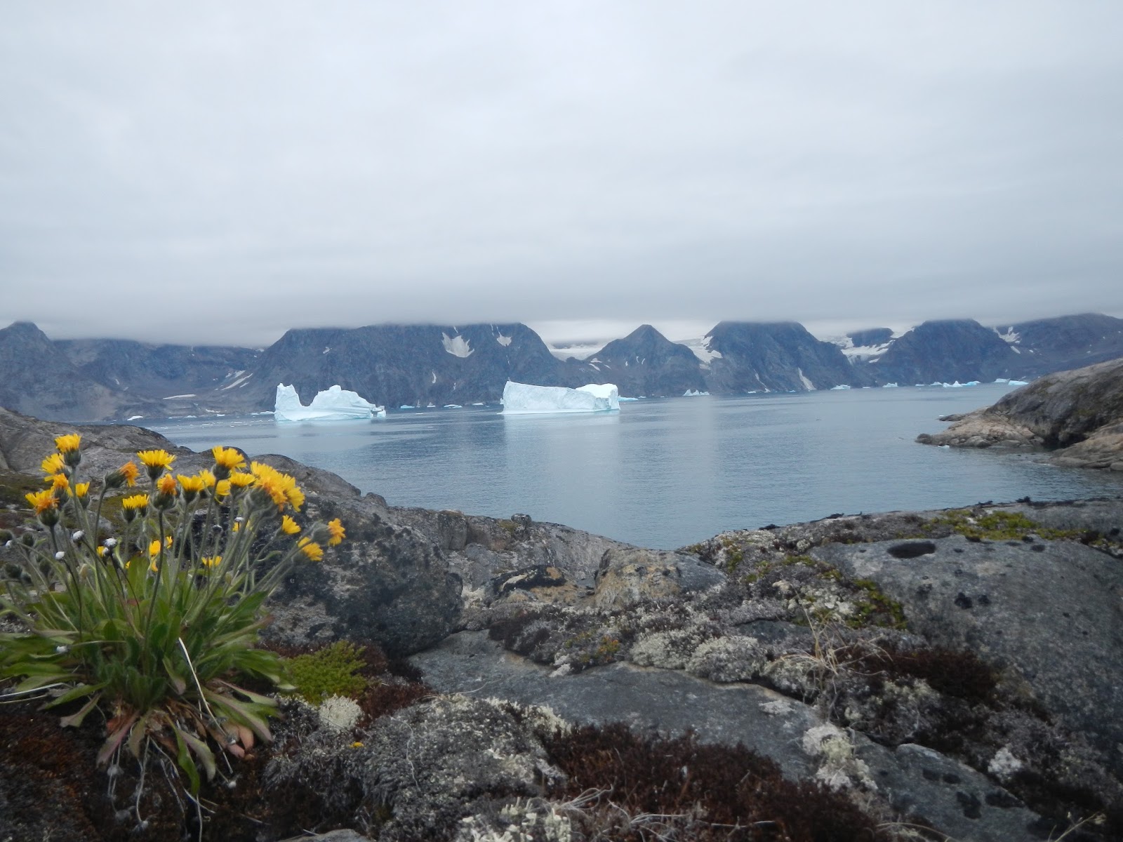
After chilling in the tent, reading and listening to music, I went for a walk up to the top of the gnoll. The view was stunning, probably the best view that I have ever seen. Kangerdlugsuatsiak is about two thumbs (10 nm ) across. On the far side to the north were four well defined hanging valleys each with its own glacier. To the east the fjord gives way to the open sea where the swell picks up. In the opposite direction to the east there is a junction of four fjords. Straight across is Nordfjord where FSC and co. put in to repair their motor boat the Stella. Next to that is the main fjord which leads to the Glacier de France. The other two fjords are Vestfjord and Odesund which is the channel between Store and the mainland.
I had another go at fishing, this time spinning off the rocks. Despite moving to various locations to all the seaward sides of the gnoll I did not get so much as a nibble. Other ways of passing the time included taking pictures of the food pouches for our kind sponsors. Geoff the team photographer was kind enough to give me some tips which I think improved the standard of my pictures. John felt restless so he paddled back to the huts at Satermit to get some firewood. We kept in touch by radio just in case he encountered an ice bear. The locals do not know them as Polar Bears. In any case the sun had gone behind the cliffs and we had a big day ahead of us so we went to bed early. It was not getting dark at all so as Gino Watkins once apparently said 'the hands on the clock were meaningless'.
Monday 01 August
We awoke early to a lovely morning. The cloud had all gone and it was a beautiful bluebird day.
Our routine was the same as normal and after breakfast on the beach we packed the boats and headed diagonally across Kangerdlugsuatsiak Fjord. Under the hanging valley furthest to the right (east) there is a beach where it is possible to land and have a break before assessing the situation and making the final decision to head off towards Hell Corner. The crossing took just under two hours and the past surprisingly quickly which was probably due the views of the coast and icebergs. About half way across a whale past just behind us. Using mu new knowledge from the Whale Museum in Reykjavik i reckoned it was a Hump Back Whale. I made a rather poor attempt to video it.
The beach is in a small cove sheltered from the open sea by a low headland. At the rear of the beach the cliffs rise sheer and the steep slopes are covered with scree. The tide nearly covers the sand at high water making this more of an emergency or lunch type beach. some of the loose rock looks rather precarious.

We had a quick coffee break and refilled our water bottles from a noisy stream that was cascading out from under a large block of ice. This stream was probably fed from a glacier in the hanging valley above us.
Once back on the water we hand railed the cliffs and made our way to the mouth of the fjord. A few kilometres on there is a large bay which marked the transition between the Fjord and the open sea. We had a quick conference to make sure that everyone was happy to proceed. From this point there was at least a five hour paddle in front of us with nowhere to land. It was important to make sure that we were all comfortable. The decision was unanimous and we set off once more.
There was a small chop and a gentle tail wind. Conditions were as perfect as we could have expected. We kept fairly close to the cliffs which meant that sometimes we took the inside line when passing an ice berg and sometimes we went around it. As usual the ice bergs were calving and the sound of breaking ice kept us on our toes.

After a couple of hours Hell Corner (Qagitsivigtaqartarajik) came in to view. The headland is quite distinctive and it has what appears to be a small triangular cave at sea level. There is a reef which heads out to sea from the base of the cliff directly off the point. The water was kicking up even on a calm day such as this which is probably due to a number of currents meeting at the headland.
We rafted up just before Hell Corner and carried out an assessment. John produced his large bag of sweets and we were all feeling quite excited. We had read about this place but I had only ever seen one photograph taken by Paul Caffin on his visit to Lake Fjord. In any event the paddle past the headland although choppy was fairly uneventful.
From Hell Corner it is just over a kilometre to Kap Japetus Steenstrup ( Nigertulup orqngmut nua ) and the entrance to Nigertulik Fjord. FSC refers to this fjord as Nigertusok. According to FSC the fjord gets is name from the strong north easterly winds that blow down the fjord from the glaciers which we could see to the north west as we paddled across. The entrance is nearly a thumb wide and it took us a little under an hour to get to the other side. There was a bit more chop here so taking pictures as we crossed was little tricky. Once across we cut inside a group of islands and looked for somewhere to have lunch. There was a sheltered bay behind the biggest island but there was nowhere to land even though Martin and John had a good look around. We rafted up once more and had lunch afloat.

After lunch we paddled along the coast and cut inside the next island through a small channel. As we emerged from this channel we could see a large island sitting at the mouth of the next fjord. This island was named Ailsa by the BAARE Expedition due to its resemblance to Ailsa Craig an island just off the coast of Scotland to the west of Girvan in the Forth of Clyde. Ailsa was easily recognisable and this confirmed that we were now at the entrance to Lake Fjord.

FSC describes the fjord on page 38 of his book. It seems a bit pointless to write about the same place and merely change the words so I take the opportunity to quote him here:
'Lake Fjord is a small Y shaped fjord, the extremities of which are only 3 or 4 miles from the open coast. A high conical island of rock, reminiscent of Ailsa Craig , after which we named it , guards the mouth of the fjord, which is rather more than a mile in width. The steep - sided north branch of the fjord terminates in a glacier wall nearly 100 feet in height, running the whole width of the fjord. This glacier, longitudinally streaked with lines of moraine debris, is fed by many tributary glaciers winding round the feet of lesser mountain ranges visible in the background. On the north side of this fjord is a narrow hanging glacier of extreme steepness.
The southern branch of the fjord leads through less rugged mountains to a wide fertile valley containing the lake, bringing down so much mud that ships must anchor long before they reach the end of the fjord'
We encountered a head wind as we entered the fjord and this created a small chop on the water and this gave the impression that the tide was flowing out of the fjord. To the left the cliffs towered above us and blocked out the sun creating a large area of shadow which was quite cold. The rest of the team chose to paddle further out in the main channel in the sunshine where they could get a better view of the glacier in the right hand branch. I took the colder route close to the cliffs out of the flow. Slowly Aisla drifted behind us and the features of the coastline at the branch junction took shape. I kept focusing on this point because this is where the memorial cross to Gino Watkins is marked on the map. Not far from this point we regrouped and eventually the cross came into view above us. We had decided to land here on the way in and visit the cross first. This would give us the option of leaving in a hurry if the weather forecast took a turn for the worst. With a seven hour paddle behind us we were feeling rather exposed.

The landing to view the cross is not an easy one. Just off to the left (west) there is a small ledge which forms a bit of a quay. The state of the tide was perfect and there was only a small swell. John landed first and assisted us each in turn. Even so, for us old folk it proved to be a bit of an effort but no one got unduly wet. We tied off the boats and cast them adrift connected by a tow rope secured to a rock. From here it was a small sometimes vertical scramble up to the site of the cross.

The view from the cross is quite spectacular and it was easy to why this spot was chosen. Ailsa is clearly visible as its it splits the entrance to Lake Fjord in two.

We each had our photographs taken and congratulated one another on getting here at last. We had all wanted to make this trip for a long time and this was my second attempt. Our team had an average age of fifty eight. Martin reckoned that only fourteen paddlers have ever paddled in and out again (excluding locals of course) and Donna is the only women to have achieved this so far. By the way apparently I may be the oldest to have done it.
I had mixed emotions, on the one hand I was feeling as if I had climbed a mountain and was standing on the summit but this was tinged with the fact that we would not be here if Gino Watkins had not died in such tragic circumstances. In any event it was not hard to have a sense of closeness to the characters brought to life by the books we had read.
Time was getting on, we had been paddling for over eight hours and we needed to get to the campsite which was half a thumb up the left (west) branch of the fjord. We retraced our steps back to the boats and successfully got afloat without any mishaps. As we paddled further in to the fjord we past many grounded ice bergs blown here by the wind. We had fun making Disney shapes from them. I clearly saw rabbits, chickens, Shrek and many others.

We landed by a scree slope with lots of debris flowing into the fjord from the glacier above. Further round to the left a river flowed into the sea from The Lake. As stated by FSC the tide goes out a long way here and we were fortunate to land near to high water. After securing the kayaks we quickly found the site of the old hut and set up camp nearby.

We explored the hut and the surrounding area. It was possible to make out the remains of the old water supply and a fish smoker. We examined what remained of the hut and found some smaller items such as sardine tins, marmite jars and other various bits n bobs. There were cables tied to rocks presumably to tie the hut down in windy conditions. Local hunters visit the fjord but they appear to camp away from the site where it is easier to land at low tide. The base camp site is surrounded by a lot of wild flowers and there are quite a few birds flying about. There is also the constant sound of running water flowing through the glacier debris near the shore. At the base of this debris Donna and John discovered the remains of an old boat. We retrieved the keel and excavated sand and rocks to reveal one side of the boat. It was about 5 metres long and quite sturdily built. Donna had a copy of FSC's book which had photographs in it. On one of the pages was a photograph of John Rymill sailing the whaler which the expedition used for fishing and general ferrying of equipment. The boat that we discovered was clearly the same boat. FSC had written that this boat had been towed out of Lake Fjord at the end of the expedition but this does not seem to be the case. We took photographs of the boat and put what we had excavated in a safe place above high water.
Everyone seemed a little subdued possibly due to the days paddle or maybe due to the atmosphere of the campsite. We sat around a camp fire as the sun went down and I spoke a passage from FSC's book which was read when the original cross was erected.
Fear no more the heat of the sun
Nor the furious winter rages
Thou thy worldly task hast done
Home art gone and ta'en thy wages
Golden lads and girls all must
Like chimney sweepers, come to dust.
Tuesday 02 August - Hell Corner Return
It was a beautiful sunny day again, but I could tell Martin was feeling edgy. It is a big responsibility to lead a trip and take the rest of us to a place as exposed as this. There was no feeling of exposure at the base camp. The weather was good, the views were stunning and there was plenty to do and see. I wanted to stay one more day but in the back of our minds there was always Hell Corner and how difficult it would become if the weather changed. The decision was made to leave at 3pm that afternoon to take advantage of the high tide.
Before we left there were a couple of things that we wanted to do. Donna and John trekked up to The Lake to get some photographs. I went for an explore around the locals campsite. On page 89 of FSC's book he refers to having breakfast with some of the crew of The Maegen a Danish Naval ship that was used for fishery protection on the West Coast of Greenland. This ship had given FSC and Quinten Riley a lift from Angmassalik to Lake Fjord.
'When Commander Reis and Lieutenant Hoppe came to breakfast with us in the hut next morning, the former told us that he had a man on board who had once been a stone-cutter and that if we agreed he would get him to carve Watkins' name and the date of his death on a large lump of granite just behind the base.'
This is the only reference that we have read which relates to this carving and none of us had ever seen a photograph. Martin had been to Lake Fjord twice before and despite looking for the carving he had not found it. We went back to the book and started again. 'Behind the hut' we assumed this meant within say fifty metres. By holding a burial service the remaining expedition members confirmed their Christian faith so the carving would probably face east. The 'large lump of granite' would need a flat section big enough to fit the lettering on it. I located a suitable section of rock on a low granite ridge behind the hut and we carried out a finger tip search. By this time Donna and John had returned from The Lake and almost at once Donna spotted an ornamental cross. We then found Gino's name and the date of his death exactly as stated in the book.

The inscription was difficult to read and did not show up in photographs so we coloured in the letters and numbers with a lump of coal from the left over supply at the hut. The carving then became clearly visible. I placed a sprig of Niviarsiag (Chamerian latifolium or dwarf fireweed/River Beauty) the national flower of Greenland below the writing and we each had a photograph taken in memory of our visit. The rain will by now have washed the coal away and Gino's name will be hidden once more.

We launched on time at 3pm and headed away down the fjord. As I passed the trapped ice bergs I once again made disney shapes. There was a head wind from base camp to the branch fjord. We kept close to the south shore in the shadow created by the large cliffs. Ailsa soon appeared dominating the view to the north and dividing the fjord in two. We found the small gap inside the first island and rounded the headland into the large bay north of Nigertusok. By this time we had been paddling for about an hour and a half so we rafted up and had a coffee break prior to the crossing of Nigertusok Fjord. After crossing the mouth of the fjord we retraced our route back to Cap Steenstrap. The sea became messy and bouncy as we approached Hell Corner. There was no pattern to the waves and we were under high cliffs constantly in shadow so it was quite chilly. The next couple of hours were not particularly interesting, we did not speak much and as a group we were quite spread out. Eventually the sun came into view shining off ice bergs out to sea. The view south to Eskimo island and Store, with all the different light patterns, was just beautiful. We rounded a headland and entered the mouth of Kangerdlugsuatsiak Fjord by the large bay. We landed on coffee break beach just after 8.30pm feeling a bit tired after the five and half hour paddle but quite elated that we had done it and got out without incident.
We had coffee and some food and launched onto a flat calm sea. The sun was starting to go behind the mountains and we had a beautiful sunset paddle passing each of the hanging valleys. We landed at 10.30 on a small beach at Ingmikerterajik and inside some huge ice bergs which were just a few hundred metres off the beach.

The boats were unloaded, moved above high water and secured with a tow line. The campsite was strewn with rocks interspersed with plenty of dry moss and covered in Niviarsiag. We set up camp and then spent time chatting and drinking hot chocolate. We were all feeling good and did not set the trip wires until after 1.30 am. It was still not dark and I was feeling apprehensive - this seemed like a good place for bears.
Wednesday 03 August - Rest day
It was a rest day but I was still up early. There was not a cloud in the sky and the views with the big ice bergs so close were once again stunning. A few hundred metres away to the west was a large stream flowing down the mountainside from a large glacier. This was a great place for a good wash down and a chance to rinse some salt out of our kit. We spent the time taking photographs, charging our batteries on the solar chargers and chilling on the beach. I watched a large group of Greenland seals swimming around the ice bergs. They then moved off along the coast and appeared to be shepherding fish to trap the against the shore. Greenland seals are quite peculiar to watch. They swim with their heads up and in groups presumably for safety.
We cooked dinner on the beach and then the temperature dropped. Mist came in and a large ice berg exploded just off the beach creating a small tsunami which luckily did not reach the boats.
Thursday 04 August - Return to Depot Island
Up early once again and launched just after 9am. We paddled through the large ice bergs but did not hang around too long. One had calved during breakfast about half a mile away and this was not a safe place to paddle, but we did get some good photographs and some video. It did not take too long for us to get out into Kangerdlugsuatsiak Fjord and we headed towards our previous campsite. From here we turned west passed the huts at Sartimit and landed on a small sandy beach for a bar and wee stop.
Once around the north end of Store we paddled into Odesund the small channel between Store and the mainland. The water was flat calm at first but a headwind soon picked up slowing our progress. By lunchtime we were at the main sandy beach halfway down Store where we had food and topped up our water bags. The headwind picked up again for our crossing over to the mainland where we paddled in the shadow of large cliffs in a choppy sea. There were some large ice bergs grounded at the base of the cliffs and we paddled once again inside some and outside others. The sea became even more messy and the waves were bigger than we had experienced at Hell Corner. We rounded a large headland, Kap Nordenskiold, and turned south west into a channel inside the island of Nipinerit. There are a lot of islands here, FSC describes them as a maize so you have to keep your wits about you. After Nipinerit we turned into another small channel Depotsund and headed northwest around the north end of Depot Island.On the shore there are the remains of a turf house and a wooden marker post. We had a good look around for a place to land but there was not a suitable spot so we continued to the main campsite at the south west corner of Depot Island and landed at just after 3.30 pm.
It was high water so we had to quickly unload the boats and move them into the gulley. It was then back into the normal routine of set up camp, brew and snooze. I was starting to switch from expedition mode into holiday mode and could feel the pressure coming off. Depot Island is a noisy campsite, the waves boom into the gulley at high tide. It was now getting cold after 6pm, the trip wires appeared to be working well so we decided to cook at the tent. After dinner Geoff and myself went for a walk up the hill. Here we found plenty of burial sites but no bones. There were also a number of stones jammed vertical into the rock. We could not fathom what these were for and assumed they were some form of navigation aid.
Friday 05 August
Short paddle day today back to Gruse. Launched at 10.15 and had a leisurely paddle across Depot Fjord to the headland at Kangikajik. On page 228 of his book FSC refers to three islands, Ananah, Katunah and Aputatik. We know that Aputatik is Aputiteq or Gruse. I am of the opinion that Ananah is Depot Island. FSC Says that the sea is vilely rough as they paddle in behind Ananah and there are old winter houses on the sheltered side of the island. The map refers to Depot sound as Ananap ikasa and Depot Fjord as Ananap kangeriva orqorteq. So Depot could easily equate to Ananap or Ananah. Of course this pure speculation especially as FSC does specifically mention survey work being carried out in Depot Fjord.
The other island Katunah is mentioned a few times as a stop over on the various journeys between Lake Fjord and Angmassalik but it is not shown on the map. One of the two islands at Fladeerne is named Qavtunaq and we surmised that this could in fact be Katunah. These islands were the next way point after Kangikajik and we decided to have an explore as we passed. The distance from Kangikajik to Qavtunaq is less than one thumb and we arrived at the islands in under an hour. We circumnavigated the easterly island which is the taller of the two. There was only one viable landing spot overlooking the sound between the two islands and we stopped for elevenses. We believe it is the westerly island that is Katunah. This island is low by comparison to its sister and it is possible to see the remains of winter houses and walls from the sea. We did not land and continued on towards Gruse.
We landed on the sandy beach and quickly unloaded the boats and set up camp. After lunch comprising flat bread and Brie we held a team meeting to decide where we were going to go next. All of us were keen to get up close to a glacier. We could go directly across to the Apusineq Glacier on the other side of the fjord from the camp. The glacier calves into the sea in a number of places and there seemed to be one spot where we could land and hike up the mountain alongside the glacier. The other option was to head north from Sermilgaq and visit the Karale Glacier. We decided on the second option. The Apusineq Glacier was very active and could prove to be a hazard and the Karale Glacier is massive by comparison.
Some of us went for a walk up on to the ridge behind the campsite. From the top of the ridge we could retrace our paddle all the way back around Hell Corner and on to Ailsa at the entrance to Lake fjord. There was a glacier pool where we went for a skinny dip. The first bath for nearly two weeks.

The terrain was a boulder field with some large rocks and patches of grit and dust much like I would imagine the Moon to look like. FSC says this island has its own permanent Ice Cap, but there is very little ice left today.
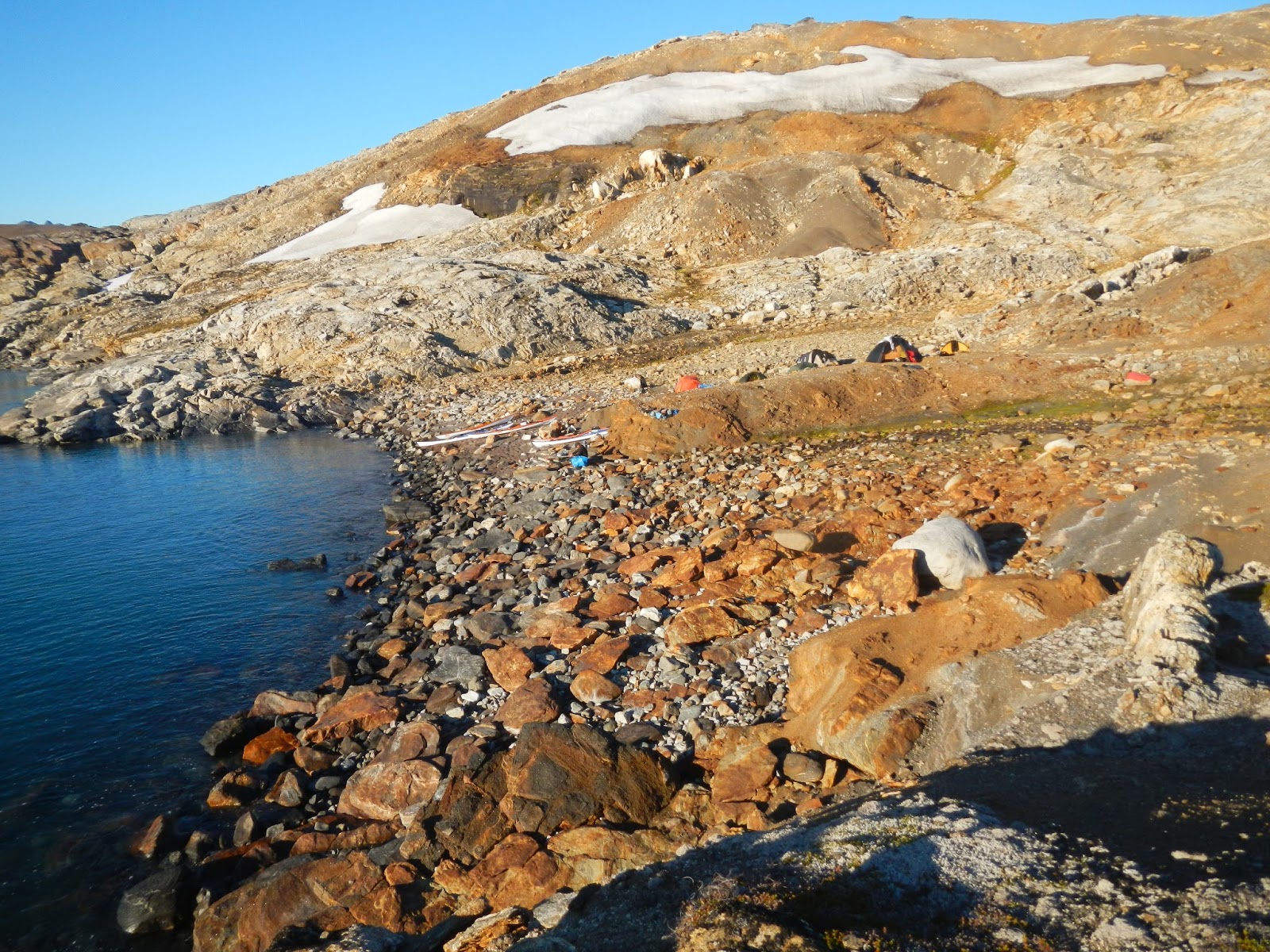
That evening we lit a camp fire and had a brew whilst Donna read passages from the book. We were travelling the same route that the BAARE members used many times on their trips to and from Lake Fjord. The glacier was especially noisy this evening and it sounded once again like we were sleeping close to a battlefield.
Saturday 06 August
Yet another sunny morning. We packed up early, had breakfast on the beach and launched just after nine. The ice bergs were very active today and minutes after we launched a set of very big waves arrived and went right up the beach and past where the kayaks had been tied off. This had a been a lucky escape for us.
Gruse was soon left behind us and we retraced our route through the gaps in the islands. There was a lot of brash ice here which makes a hideous noise as it bumps along the kayak. I felt quite guilty as I thought of Martins gel coat.
After lunch on the picturesque sandy beach we paddled through the small gap on the East side of Annlinarteq and on towards the next headland. As we rounded the headland the wind picked up to force four/five directly into our faces. We struggled to make headway and eddy hopped along the north side of the fjord trying to keep out of the wind. At one point I thought that we may have to run into a fjord to the north of us and find a campsite in unexplored territory.

However, we managed to find shelter behind two islands on the other side of the Fjord and eventually made it safely to The Slabs campsite. at around 3.30 pm.
We unpacked, set up camp and had dinner sitting in a pit amongst the rocks out of the wind. It is starting to get very cold when the sun goes down so we went to bed early after first setting the trip wires. There is still daylight twenty four hours a day which is easy to get used to. Time seems to just drift on by. Gino is reputed to have said 'what does it matter what the hands of the clock say' and I now understand what he meant by that comment. We did not need an alarm, Geoff is an early riser and went around waking us each in turn.
Sunday 07 August
Up early and breakfast on The Slabs. It was yet another stunning day with not a cloud in the sky. There was a very relaxed holiday atmosphere around the camp and we were all well into our expedition routine. We wanted to catch the supermarket so we launched at nine and headed off south towards Sermiligaq. There was a large flat iceberg in the middle of the fjord so we stopped for team photographs and arrived at Sermiligaq around ten thirty. The Pilersuisoq did not open until eleven and there was a queue of curious locals waiting outside alongside us. I had been living on expedition meals for ten days and it was nice to stock up on lots of goodies such as chocolate Swiss rolls, honey, biscuits and the ever faithful Coffeemate.
We left Sermilgaq and paddled north into the next bay at Kungermit. There is a replica hut here which has been built as part of a schools education project.The way to the hut was guarded by a pack of sled dogs. The leader of the pack was sunning himself on a rock and did not seem phased by our presence. Inside the hut there is a sleeping bench and various bits and pieces such as cooking implements and children's toys. There was not a lot of light in the house, the window was boarded up and to be honest it was not very inviting. I would not have wished to sleep there but we did get a good feel of what life for the old Inuit must have been like.
Our campsite for the evening was to be at Nunartivaq some three thumbs to the northeast across Sermiligaq Fjord. We paddled in a direct line out into the middle of the fjord. The wind was light and the sea flat calm so I decided once more to try my luck at fishing. I let all of the line out off my hand line which took the lures down to a depth of 50 M. However, I came to the conclusion after some two hours that there are no fish in this part of Greenland.
We land on a lovely sandy beach previously named Surf Beach. This is because the beach faces due east and the fetch comes directly off the The Denmark Strait. At the back of the beach is a low rocky ridge upon which it is possible to pitch half a dozen tents. Behind this ridge is a sheltered low flat area where any number of tents could be pitched if the weather was inclement. A wide bubbling stream feeds out of the glacier valley beyond the campsite. The islands and the area surrounding the stream are covered in Niviarsiag. Near to the beach a large rock pool gave us the chance to have a swim and rinse off our dri suits in fresh water. The weather was fine so we all camped up on the ridge which meant that we had an amazing view, out over the fjord and beyond, straight out of the tent doorway.

Our evening meal was cooked near the tents where a low rock step provided a comfortable seat with a view. I went to sleep listening to the sound of the waves breaking on the sandy beach.
Monday 08 August
Slept well up early and after breakfast on the rocks we launched just before ten into small dumping waves. We handrailed the coast north and rounded the point at Nugartik. After an hour we pulled up a beach for an early lunch. across the fjord to the north east we could see The Rasmussen Glacier which was over four thumbs away and looked enormous. To the right of this was a range of peaks interspersed with many hanging glaciers. Around to our left and still out of sight was our goal The Karale Glacier. The map shows the Glacier to be about one thumb form here. In reality it has retreated many miles since the map was drawn and was in fact still over two hours paddling away.
After our break we paddled off the beach and almost immediately rounded a small headland and the the Glacier was in full view. We could see it clearly but it was over ten miles way and did not seem to change as we paddled towards it. To our north was a smaller glacier which was constantly calving and kept us entertained on our journey. I picked out lumps of ice, lined them up and used them as targets to reassure myself that I was actually making progress down the fjord. The scale of the landscape in Greenland is impossible to get used to. The mountains do not look much larger than the ones in say Scotland until you realise how far away they actually are.
Eventually, we landed on a sandy beach among large blocks of ice and glacier debris. Three of us walked up to the face of the glacier to have a photo shoot wearing our kayak gear.

I had not realised how messy a glacier and the surrounding area was. It was like walking through a quarry back home. The rock was ground totally smooth and covering this was a thin layer of dust and small rocks. This was a lethal combination for walking and I took a heavy tumble after which I walked with much more caution. The glacier itself towered above us.

There were many caves and fissures in the face but it was very peaceful by comparison to other glaciers we had seen on the trip so far.


We set up camp some distance from the glacier. The terrain was rock and dust very much like the campsite at Gruse.

The temperature had dropped considerably and there was a constant chilling breeze coming off the glacier. It was like living in a fridge.

After dinner we sat on a high rock looking at the views and chatting about such things as global warming. It was cold in the tent that night and I suspect we were all wearing a couple of extra layers of clothing.
Tuesday 09 August
Lazy start due to short paddle day back to surf beach. The dust and sand was becoming a right pain. It gets everywhere including inside the tent and covers everything in a white dust. Two of us went for a short walk up to the face of the glacier. As mentioned the terrain was lethal to walk on so we took I time. We stopped a safe distance away form the face but close enough for us to study it. The ice was not white at all and looked very unstable. There were pillars and caves and large lumps of ice which looked like they were ready to fall into the sea at any time. At the margin the ice was mixed with stones and dust in a very uninviting frozen mixture which we were actually standing on whilst we made our study and took photographs. The 'tide' line was clearly visible around the valley side showing how much the glacier had receded in recent years.
Once back at camp we had a quick brew and launched around eleven thirty. The trip back to surf beach went very quickly and we landed at 3 pm. Over towards the south side of the beach a pile of kit had been offloaded whilst we were way. A short time later a large group of over fifteen walkers turned up and set up camp, including a massive tent, high up on the rocks. The feeling of being alone in the wilderness had now gone and for the first time in nearly three weeks I got to thinking that it would soon be time to head home.
Wed 10 August
Feeling tired today, I did not sleep well last night because I kept sliding down the mattress due to the tent being pitched on a bit of a slope. This is one disadvantage of a Synmat.
We had another lazy start and launched around 10.30. We soon overtook the walkers who shouted a cheery hello as we passed far below them. I did not envy them at all if I was honest. There are no trails in the wilds of Greenland and they were scrambling along the side of a hill. Martin met a couple of them later in Kummuit and they remarked that they envied us gliding along.
Our route was south west into a fjord called Ikateq and on to the Bluie 2 Airbase. I had visited the Airbase three years ago but it was still well worth another visit as we were passing. We had arrived from the south last time and this time we were coming in from the north. Our lunch stop was at the harbour that had been built by the Americans to service the base. The crane used to off load the ships was still there parked near to the quay. It looked quite impressive so I had a sit in the drivers seat. The controls were all rusty but you still had the feeling of what it must have been like to drive it.

I wanted to get one of my friends a souvenir from one of the vehicles, he likes old tractors and such like so I thought he might appreciate a wheel nut.

We had a walk around and took some photographs. The runway showed signs that a plane had recently landed. There is mounting pressure to have the Americans clean up the area and a check on the internet revealed that a high powered delegation had recently visited, presumably to have a look at how much work is required. I have mixed feelings on this. On the one hand the airbase is a piece of history literally frozen in time attracting visitors but it really is a mess that should be sorted.
With Geoffs' help I manged to get my wheel nut plus a rusty window catch.

We continued our journey to a large junction on the west side of the island of Qianarteq. Here we turned north west into a fjord called Tuno. This fjord leads to a narrow stretch of water which eventually leads to the settlement of Kungmitt. The narrows are tidal and high water is needed to ensure sufficient water to float a kayak. This is only possible because the Americans blasted a way through to provide a shorter more sheltered route form the Airbase to the Kungmitt.
We camped on a flat windy area just short of the crucial point. I tried my luck at fishing but had no luck as usual. This area is well used compared to other camp sites which reminded us that we were getting closer to civilisation. There was plenty of drift wood lying around so we had a campfire.
I was camped closest to the water and during the night I was woken by the sound of something large paddling through the shallows close to the tent. Instantly knowing what was making the noise I attempted to make a quick exit from the tent to warn Martin who I knew had the gun. First I had to get out of the sleeping bag, this proved to impossible due to my panic state. Eventually, I managed to extricate myself from both the sleeping bag and the tent. By this time the bear was long gone presumably spooked by the still burning fire. I woke Martin who surprisingly believed all my babbling words. He conducted a sweep of the surrounding area but found no sign of the bear. I was trying to convince myself that I was not dreaming but I know what I heard and it was definitely a bear. The locals call these bears 'Ghost' bears. You never see them but that does not mean they are not there. After this a bear watch rota seems suddenly more like a good idea especially as we were only a short paddle from quite a large settlement.
Thur 11 August
Last day paddling, Kungmuitt was only a couple of hours away. There was no rush to leave, it was going to be short day on the water and we had to arrive at the narrows at high water. The weather was chilly but very calm. There were some spectacular reflections on the water and the only sound was a distant water fall and some noisy Eider ducks flying past the campsite.

We arrived at the narrows shortly before high water and sat on some rocks to pass the time. After a bit of wading, pushing and shoving we managed to get through and into the deeper waters on the other side. We were still in no rush and the suggestion came up to try one last chance at fishing. My success rate on fishing was pretty poor but Donna said that she had seen fish at this exact spot. We rafted up and I let most of the hand line out until it touched the bottom. I then pulled it up a couple of metres and we sat there chatting while I was jigging.
Rassmussen tells a story in his book ' Greenland by The Polar Sea. The tale is about Nerrivik who is the Goddess or Mother of the Sea. She is known by many names such as Sedna (Inukittut) or Arnakuagsak in Greenland and Sassuma Arnaa in West Greenland. Nerrivik is an orphan girl who lives with a large family. One day it is time for the family to move on so all the equipment is packed into their Umiak and they put to sea. Unfortunately, Nerrivik is left behind on the beach. She shouts to the family but they ignore her cries so she jumps into the sea and swims after them. When she reaches the boat she clambers on to the gunwhales but one of them cuts off all her fingers and she sinks into the sea and drowns. Her fingers become the whales and seals of the sea and she lives in a house with no roof on the sea bed.
When she is displeased the hunting is poor and the weather is bad. The Shaman then has to go into a trance and swim down to comb the lie out of her hair and convince her that the people up top are not that bad. If he succeeds the hunting and weather will improve.
I often talk to the Mother of the Sea when I am in a sticky situation such as a large tide race or noisy cave and she usually stops my disco leg from shaking and all is well.
Today, I had a little chat with her and she was in a good mood because after about five minutes I caught a really nice Cod which I passed over to Martin who quickly dispatched it and popped it into his kayak. One fish was not going to feed us all at dinner so I tried my luck again and caught an even bigger one. I was well chuffed. All I had heard on the trip so far was how good the Italians were had fishing. After this catch I heard no more and I duly thanked Neverrick for her gift.

We visited the Pilersouq at Kungmuitt and purchased some potatoes and vegetables to go with the Cod which was cooked on an open fire. We set up camp close to the drying rack of the under used fish factory to the north west of the settlement. Here there is an area of raised flat ground which gives a great view down Angmassalik Fjord. We had a great view of two Hiumpback Whales swimming together out in the Fjord.
After dinner the local hunters returned to the settlement in their boats following a few days away hunting. They first congregated on the far side of the Fjord and let off a loud volley of shots. All thre boats then raced across the water and into the harbour. FSC mentions in his book about the tradition of firing shots to alert a camp when they were arriving. Having witnessed this first hand I now felt like a tourist.
Fri 12 August
No paddling today. We packed our kit bags instead of the kayaks and sat around waiting for the boats to arrive. Our pick up arrived at 10.30 and we were soon on our way back to Tasiilaq.
The rest of the trip was fairly routine apart from the pizza place being shut so we did not come off expedition food for another day. It was also shut the next day but I managed to buy some nice food from the supermarket.
We packed all the kit away ready for the winter and did some tourist stuff. We met Dina from the tourist information place who very kindly arranged for a Drum Dancer to visit our campsite and give us a cultural display to round off an amazing trip.

He told us a few stories and one about the Raven who wished to be a seagull I had read previously in FSC's book.
Sat 13 August
An early start, our kit was quickly packed and moved down to the rocks ready for our boat pick up.
Soon after we were on the plane and that was Greenland until the next trip.
Conclusion
I started kayaking in 1968 when my school teachers decided to take a group of us on a trip to Wales. They decided to give us some on the water experience first in skin on frame kayaks. They were surely carrying on the tradition started by the returning members of the two BAARE expeditions. Kayaking has been a huge part of my life so it was an amazing adventure for me to go back to where it all started.
This expedition has paid homage to the men of the BAARE and especially to the memory of Freddie Spencer Chapman, Gino Watkins, John Rymill and Quintin Riley.


Comments